Walking Tour - Trafalgar-Allan Corridor
Start/End Point:
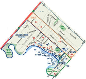
This tour starts at Trafalgar Road and Old Mill Road: follow the points of interest on the map.
1. The Mills on the Sixteen (1827)
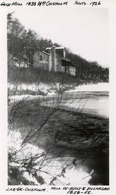
A crucial step in the development of any settlement was the construction of saw and grist mills to provide basic building materials and foodstuff for local consumption and export. The site William Chisholm chose for the mills - both a sawmill and gristmill - was at the "head of navigation on the Sixteen, where the rapids end and the water runs deep for about a mile before entering Lake Ontario." This was on the east side of the creek, near Old Mill and Speers Roads. Construction began during the winter of 1827-28 with the building of a dam, as a dam was an essential part of a mill and the best time to build one was in winter, when the water was low.
In 1830 the sawmill went into production and construction of the gristmill adjacent to it was started. By 1833 it was in production.

"The painting...The Mill on the Sixteen shows the mill as viewed from the top of the east bank of The Sixteen on Dundas Street [Trafalgar Road] south of the 6th line [Old Mill Road, Lyon's Lane]. ...in the background a train is passing over the wooden trestle...[and] in the foreground is Snake Island which has long since disappeared; at the time...it was the haunt of black water-snakes six feet long and mud turtles large enough to carry a man standing on their backs."
2. Wildlife (1830s)
The wolves that were so plentiful in the back country frequently followed the valley of The Sixteen almost down to the village, and could be heard howling at night in the vicinity of the mill.
In the Spring, the Sixteen abounded with Atlantic Salmon; in fact, one eighteenth-century French map shows it as "Rivière au Saumon". The fish ran up the St. Lawrence into Lake Ontario in great numbers to spawn in rivers and creeks, where they were taken in large quantities. Weighing from fifteen to eighteen pounds, the salmon were easily caught, a night's catch sometimes filling eight or ten barrels. When salted down the 200-pound barrels sold for 30 or 35 shillings each.
Fishing in The Sixteen is thus described by Mr. Warr (an Anglican clergyman):
"The mode of fishing practised by the Indians is exceedingly interesting. The operation is carried on at night; two men generally steal along with the utmost caution in their canoe; the one uses the paddle, the other the spear; the former sits in the stern, the latter stands at the bow of the boat; the invariably carry a large piece of pine lighting in a grate which is so arranges as to cast a strong glare upon the water and enable the spearman to see the fish which he strikes with his harpoon with an unerring aim, and instantly throws it into the boat..."
The salmon stopped running during the 1840's..., perhaps because of over fishing and the contamination of the water by sawdust from sawmills.
3. Muskets (1830s)
The section of Oakville along Dundas Street (Trafalgar Road) between George's Square and the mill, and east through Anderson's Bush, is described by a resident in the 1830s as "the place where we gathered in the spring and fall with our old flint-lock muskets and shotguns, to fire at the millions of wild pigeons which used to fly over the town".
4. Samuel Lawson's House (1837) - 280 Lawson Street

It's likely that Samuel Lawson and his family were the first to settle so far north of the village proper, as no other houses existed between theirs and Potter's at Sheddon Street at the time (1837). Wanting to build a house for his family but unable to finance both the purchase of land and a house, he obtained from Wm. Chisholm title to park lot K, for which he was to pay when he could. He built a one-and-a-half story house of hand-made brick (the first in Oakville) on the property, facing Trafalgar Road and surrounded by an apple orchard. Over time the street bordering the property on the north became known as Lawson Street.
As it happened Lawson never succeeded in paying for the land, and knowing this, his last descendant willed the property to a grandson of William Chisholm. The house stood vacant for some time, and there was little left but the brick shell to use in the significantly renovated structure that exists today, now facing onto Lawson Street and bearing the municipal number 280. The apple orchard of course is long gone, occupied instead by several houses.
5. The Breweries (1840)
Whisky and beer are by-products of the grain business. The Oakville Brewing and Distilling Company began operating in 1836 on Walker Street, overlooking the harbour. One of Oakville's leading industries during its short existence, it distilled sixty gallons of whisky a day.
Another brewery soon started up close to the river bank on Dundas Street (Trafalgar Road) at Division (MacDonald) Street - the steam brewery - of which James Brown was proprietor in 1858. About 1863 Henry Hogben took over this business, which later became "Mr. Townsend's Brewery". When Francis J. Brown became proprietor, about 1870, he called it the Victoria Brewery. It ceased operation in 1870, and four years later became the new Chisholm basket factory (see "Strawberries & Basket Factories" below) . Hence that stretch of Trafalgar from south of MacDonald Road to 6th Line was often referred to as Basket Factory Hill.
6. & 7. A Toll Road and the Toll Keeper's House (1850) - 293 MacDonald Road

By the 1840s traffic bringing goods down to the port from as far north as Owen Sound was so heavy that it was decided to improve the 7th Line (Trafalgar Road). Wood being so plentiful, the surfacing of roads with wooden planks was becoming popular, and in 1846 the Trafalgar, Esquesing and Erin Road Company was formed to build a plank road from Oakville to Fergus, a distance of about 100km. Construction got under way in April 1850 and the first 30km stretch from Colborne Street (Lakeshore Road) to "Stewart's Town" was completed in 7 months.
To provide for maintenance and repair costs, toll gates were installed every few kilometers. In Oakville a toll gate was installed at the junction of the 6th and 7th lines (in the vicinity of where Inglehart and Trafalgar currently intersect).
Donald Campbell (a tailor) was given the position of keeper of that toll-gate. He purchased a lot at the northwest corner of MacDonald Road and Reynolds Street (now 293 MacDonald) for £100 (approximately $400) and built his home there.
Many years later, the home's windows have retained the original six-over-six sash as well as the original shutter blinds, and a later addition to the rear of the house integrates well with the original stone tail. The two-story front facade is unique in that it displays a fine pattern of Flemish Bond with a cornice of decorative brick work and brick returns at the eaves. The lower story at the rear and on the two sides, like the foundation, is constructed of roughly laid river stones.
By the mid-1850s, the traffic along the toll road was enormous. Nevertheless, the road was not a success. Plank roads in general were simply not durable and had to be rebuilt every 5 years, and in April 1856, presumably reflecting the deteriorating condition of the road, the Company announced that no further tolls would be collected. Two years later the Company declared the road to be unserviceable and that it was unable to reconstruct it. The remnants of the planking were finally removed, and mud and deep holes once again returned to Trafalgar Road.
As an aside, Trafalgar Road has had many names over the years: Dundas Street., River Road, Station Road, Basket Factory Hill (S. of MacDonald to Inglehart), and , simply, Toll Road.
8. Strawberries & Basket Factories (1860s )
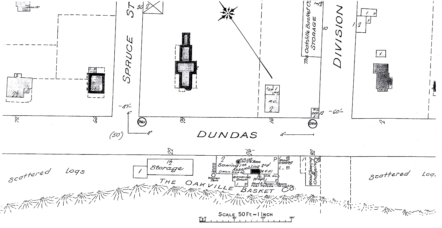
Strawberry growing was introduced to Oakville by John Cross, who farmed to the north of the Railway (Cross Avenue). To support the shipment and sale of the delicate fruit, Cross designed and began manufacturing wooden veneer "strawberry" baskets in the 1860s. John A. Chisholm soon followed suit, setting up basket production in a shed at Division Street (MacDonald Road) that used a wood paring device developed by his son Charles. By the mid-1870's Oakville had become the greatest strawberry growing district in the Dominion.
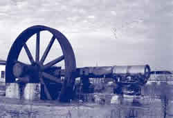
After the Victoria Brewery ceased operation the Chisholms' expanded basket operation moved into that building (by the Creek at Trafalgar and MacDonald) in 1874. In 1889, Pharis Doty & Son took over the Chisholm factory and three years later founded the Oakville Basket Company. Fire destroyed it in 1893, but it was rebuilt, to be burned down again in 1920. It was again rebuilt, further to the north, south of the railway, and remained in operation until 1984. That site until recently (2001) was marked by the flywheel which powered its operations. That artifact is now part of the Oakville Heritage Trails "Pioneer Industry" pavilion which overlooks The Sixteen from its banks on the south side of Speers by the former Old Mill Road.
Nesbitt House - 411 Trafalgar Road
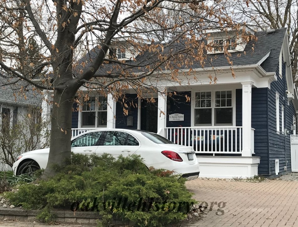
George Burton Nesbitt bought the house in 1949 and lived there with his wife Marion and his four children and lived there for 15 years. Having only four children was big change from the large families of the 1800s.
9. Mariners' Home (1862) - 279 Lawson Street

Across the street from Lawson's house, at 279 Lawson Street, is the "Mariners' Home", built in 1862 by Captain Robert Wilson. It earned that title because of the owner's custom of giving a home to ill and homeless sailors during the winters.
Captain Wilson was also loved by many black people whom he had helped to escape slavery during the U.S. Civil War, giving them space as stowaways in his grain vessels returning from the U.S. since the Town of Oakville was the gateway to Canada for many African Americans, as early as the 1830s. For years following the American Civil War (1861-1865), African Americans would come to George’s Square to celebrate Emancipation Day, and those who had been helped by “Captain Robert” would visit him at his nearby “Mariners Home”.

Originally the house, facing Station (Trafalgar) Road, overlooked a spacious lawn and garden. The lawns are still there, along wtih driveways for two other homes. To the left of the house in this photo remains a lovely expanse of lawn and garden.
In the early 1900s this was the home of John Kelley who, amongst other things, was the Mayor of Oakville.
Herbert Ashbury House (1914) - 420 Trafalgar Road

In 1914, Herbert Ashbury purchased a small piece of land owned by the Oakville Basket Factory where his house was built the same year. The factory was a busy enterprise, employing many people from Oakville and producing three quarters of a million baskets per year to hold the large amount of various local crops for transport to the city markets. The factory suffered a disastrous fire in 1920 and was relocated farther north to south of the railway tracks.
Herbert Ashbury would have wanted to live in close proximity to a different busy enterprise though, which was his father's mill located on the river bend down the steep hill and slightly upriver from his newly purchased house.
The Ashbury family owned the Mill from 1900-1927, and Herbert and his brother, Lorne, worked alongside their father. The historic Mill, built in 1827 by William Chisholm, had several owners, including the Chisholm Bros. (1833), Isaac Warcup (1870), Foulds & Shaw (1890), Thomas Ashbury & Sons (1900-1927), and lastly the Hammond Bros. before burning to the ground in 1930.
When the Ashbury family acquired the mill, they installed modern machinery which included the largest overshot wheel in Canada. It must have been quite the sight from the banks of Herbert Ashbury's house around the bend of the river at the top of the steep hill.
Herbert Arthur Ashbury was born in 1876 in London, Ontario to parents Thomas and Sarah. The family, including brother, Lorne, relocated to Blyth before settling in Oakville where father Thomas purchased the Mill. May, a sister of Herbert and Lorne, passed away in 1901 at the age of seven.
Herbert married Lottie Lusk, daughter of Charles Horace Lusk and Jerusha Ann Potter, in 1906 in Oakville. The Lusks and the Potters lived further south on Trafalgar Road where Lusk had his medical practice and Potter built at least three houses and had his shipyard. Herbert and Lottie had three children: Doris (1907), Ivan (1910) and Edwin (1915). They attended St John's United Church where Herbert served as the chair of the finance committee. In 1917 Thomas died and the mill was run by the sons until the untimely death of Herbert in 1927 at the age of 51.
Lorne Ashbury House (1915) - 423 Trafalgar Road

This house is another one owned by the Ashbury family who operated the mill located on the river bend down the slope from what is now Cornwall Rd. The mill was run by Thomas Ashbury and his sons Herbert & Lorne from 1900 to 1927, and carried on by the sons after their fathers death in 1917.
While Herbert lived on the west side of Trafalgar Rd. at the top of the bank of Sixteen Mile Creek, his brother Lorne purchased land across the street where his house was built in 1915.
Lorne was born William Cecil Lorne Ashbury in 1882 in Linton, Ontario to parents Thomas & Sarah Ashbury. In 1900, the family relocated to Oakville when father Thomas purchased the mill. The family lived in a house which was located at the top of the hill above the mill on the west side of what is now Old Mill Rd. It has since been demolished.
In 1915, Lorne married Ethel McKenzie who was from Toronto and they settled into their newly built house in Oakville, where they lived with Lorne's mother when she became a widow in 1917. Lorne's brother Herbert passed away in 1927 and the mill was sold.
Ethel Ashbury died in 1943 and her husband Lorne died in 1955.
10. Kerosene Castle (1860s) - 337 Trafalgar Road

On the bank of The Sixteen between MacDonald and Lawson Street, Richard Shaw Wood established The Oakville Oil Refinery, which became one of the largest refineries of "coal oil" (kerosene) in Canada (until it was destroyed by fire in 1866).
Across the street, at what is now 337 Trafalgar Road, he built what became known as, for obvious reasons, "Kerosene Castle". You'll recognize it today as MacLachan College.
13. The Captain Francis Brown House (c1873) - 289 Trafalgar Road

Francis John Brown arrived in Oakville from England in 1867, drawn by the discovery of oil in western Ontario. He married shortly after his arrival, and bought the old brewery on Trafalgar just north of MacDonald, renaming it the Victoria Brewery. But by 1870 a depression started to close in on the town, forcing him to shut down the brewery. In that same year, Brown inheirited the property at 289 Trafalgar Road from the resolution of the long-contested will of his wife's grandfather, and during 1871 had a house built there.
From 1879 to 1889 he sailed extensively in the Orient, and over the years gathered a vast collection of rare and beautiful bronzes, ivories, embroideries, and vases. Following his return he held the first exhibition of his collection at his imposing residence on Trafalgar Road.
Many families have lived in the Francis Brown House since the turn of the century. and numerous changes have been made to the structure, but none has affected its dramatic appearance. The Captain Francis Brown House is one of those rare cases where a widow's walk actually did provide a vantage point for the waiting wife.
14. In the Beginning (1806 - 1810)
In 1806, shortly after the Mississauga Purchase, Lot 12 was granted to Samuel Fraser, an American settler. This lot was somewhat narrower than the others due to the position of the Mississauga Indian Reserve boundary, and in compensation Fraser was also granted 50 acres across the road in Lot 11.
Fraser developed a farm on the property and, in 1810, sold the southern portion of Lot 12 - about 100 acres - to Charles Anderson, a native of Ireland who had settled east of the Forty Mile Creek on the main road between Niagara and Burlington Bay in what is now Grimsby.
13 Anderson owned other land in the Oakville area as well (lot 13, 2nd concession, bordering Oakville on the north).
15. Sale of the Land of traitors (1819)
Also living on Fraser's farm were James and Mary Gugins and their four children.
With the declaration of war by the U.S.A. on Britain in 1812, Fraser joined the American forces, but before departing he executed deeds leaving all his property in Trafalgar Township to Mary.14 John Gugins joined the British forces in defense of Upper Canada.
Mary's father was instrumental in the explosion of the powder magazine at Fort York in which dozens of Americans died, but in the process received serious head wounds himself. He was taken to Mary's home on the Fraser farm, where he soon died. (The American commander burned the Upper Canada Parliament buildings in retaliation for the explosion).
Neither Gugins nor Fraser returned from the war, but Mary continued to live on the land for some years before learning that by reason of Fraser's "absconding", the land had been forfeit to the Crown. Upon appeal, she was allowed to retain the property in Lot 11, where she lived with her children and second husband. On May 24, 1819 Fraser's land - the northern part of Lot 12 - was sold at auction under the title 'Sale of Land of Traitors'. It was bought for £75 by the owner of the southern portion, Charles Anderson.
16. Joseph Brant Anderson (1800 )
Charles Anderson was a close friend of Mohawk leader Joseph Brant, having constructed several buildings for him. Brant frequently stayed with Anderson when visiting the Forty Mile Creek area (Grimsby), and when Anderson's son was born in 1800 he was given the name Joseph Brant Anderson in honour of the Mohawk leader.
Local legend had it that Joseph Brant offered Anderson 200 acres of land bordering the Indian Reserve on The Sixteen to name his newborn son after Brant, and that was supposedly how Joseph Brant Anderson secured the 200 acres that was Lot 12. The legend was false,15 but Lot 12 nevertheless became known as "Brant's Wood", which in turn provided the name Brantwood Survey (see below) some 107 years after J. B. Anderson's birth.
Charles Anderson gave his Oakville property to his son who built a log cabin for himself and his wife on the land in 1826, close to the road , which at the time was little more than a footpath but would eventually become Lakeshore Road. Here J. B. Anderson developed a farm and replaced the log cabin with a larger home in 1836 - the same year his son Cyrus was born. When it burned down in 1895 it was said to be one of the oldest frame dwellings in the town.
17. The shot heard through town (1902)
In the 1870s Cyrus W. Anderson (1836 - 1920) , J. B. Anderson's son, built and lived in a magnificent residence known as the "Grit Anchorage" on the north-east corner of Allan Street and Colborne (Lakeshore) Street East.17 where he frequently entertained the leading Liberals of the day (this in a Conservative town). He was in the habit of placing a lamp in every window whenever a Liberal was elected in Halton. He also ran a successful 200 acre farm (Lot 12) and in 1887 established a private bank housed in its own prominent brick building (The Anderson Block) on Lakeshore Road E. (134 - 138 c2006) near Navy. All that came to an abrupt end in December 1902, when Anderson's bank and the only other bank in town (Andrew & Howarth's - also private) failed within 2 1/2 weeks of each other.
The first sign of the disaster came at noon on December 1, when a shot rang out on Colborne Street . Thomas Howarth had committed suicide in his office next to the Oakville House. A run on the banks ensued, with Anderson's bank failing on Dec. 18. Nearly everybody in town was affected by the failures, most of them devastatingly. The Andersons' 500 depositors, many of whom had entrusted their life's savings to the bank, ended up with 2 1/2 cents on the dollar. Cyrus Anderson and his sons lost everything: the "Grit Anchorage", the 200 acre farm, the bank, the Anderson Block...
18. The Brantwood Survey
The Bank of Hamilton was the principal creditor in the Anderson Bank bankruptcy and, to help recover its losses undertook a large subdivision on what had been the Anderson farmland - the "Brantwood Survey". The Brantwood Survey was bounded by Lakeshore Road, Allan and Spruce Streets and what became Gloucester Avenue. By 1909 roads had been laid out and graded and new cement sidewalks ran north, south, east and west. Within a few years sewer and water systems were added. Around 1916 the entrances to Brantwood were marked by large square stone pillars on either side of Gloucester, Watson, and Douglas avenues, lending an air of elegance to Colborne Street East.
Although all the services were in place, houses were conspicuous by their absence for some years. But by dint of much advertising and the untiring efforts of W. S. Davis (see links below*), who was the chief agent of the Cumberland Land Company (which was in charge of the project) as well as being local manager for the Bank of Hamilton, by 1911-12 the area began to fill up.
"When Spring and Summer arrived, the great attraction was to the many wooded areas in and near town. Nearest at hand was "Anderson Bush" the wooded part of the "Brantwood Survey" between Palmer and Spruce and from Douglas to Gloucester Avenue, and lovely wildflowers grew in the thick woods. Anderson Bush could be reached quickly after school or on weekends by children's ever-present roller skates and bicycles."
The idea of roller skating in the new growth forest bush that had grown up after the cutting of timber in the 1800's may seem strange, but remember that although the sidewalks for the Survey had been laid out, much of the area remained vacant for many years.
19. The Gloucester Avenue Railway (1912 -15)
As Francis Ahern described it:
"There was at first no sign that there was ever to be a Gloucester Avenue, even though the other Brantwood streets had been graded and provided with sidewalks, and it was not until 1912-13 that the road allowance was cut through the dense bush up to the northern boundary [of the Brantwood Survey], Spruce Street. The decision to open up Gloucester at this time was made because the long-hoped-for paving of the Toronto-Hamilton Highway [Lakeshore Road] was shortly to be extended to Oakville from Toronto." All materials to build the road would be coming by rail, and using the Gloucester right-of-way through Anderson's Bush to move the materials to Lakeshore Road provided the least inconvenience to residents.
Gloucester Avenue looking south c.1915
"Accordingly, a narrow-gauge track was laid the length of the newly cleared Gloucester Avenue from the Grand Trunk (C. N.) railway tracks down to Colborne Street, and on it a small steam 'doney-engine' with a long string of dump-trucks in tow ran a frequent shuttle service carrying all supplies throughout the local construction of the highway. The ...highway was completed through Oakville in 1915. It may be that not very many of the townspeople realized that all this was taking place in their usually peaceful "Anderson's Bush"... However, I lived then on my father's nine-acre fruit farm on Centre Avenue (now no. 317 Gloucester) and witnessed all these exciting happenings with my very own eyes!".
20. "Grit Anchorage" Finch-Noyes home (1870s)
The large home on the north-east corner of Allan Street and Lakeshore Road built in the 1870's by C. W. Anderson (the "Grit Anchorage" - see The Shot Heard Through Town above) is fondly remembered by many Oakville residents as the Finch-Noyes home. Nine years after seizure of the property by the Bank of Hamilton following the Anderson bankruptcy, the property was purchased by E. Finch-Noyes from Hamilton.
Francis Ahern describes it as follows:
"The lovely Finch-Noyes property, comprising the block from Colborne to Randall Street and from Allan Street to Douglas Avenue, boasted huge trees surrounding a large, white frame-house of unusual architecture. Lovely lawns and smaller trees in the vicinity of the house were contained by a white picket fence. White gates at the corner of Colborne and Allan Streets opened onto a shaded driveway leading to the house, and an entrance at the east end of Church Street led to the stables and the back of the house. The land at the Douglas-Colborne corner was very low-lying and, being fed by springs, was marshy and overgrown with bulrushes and swamp-grass. The house had been the residence of C. W. Anderson until the failure of his private bank in 1902. Mr. J. T. Madden and his family lived here for a few years until E. Finch-Noyes from Hamilton bought the property in 1911. The lovely old home was demolished in the 1960s and a large apartment complex now covers this block."
(John Caulfield Smith, spearheaded the fight by area residents against the demolition of the magnificent old home to build what is, in the opinion of one local architect, "the most inferior building designs in the history of the town.")
