
|
|
In the Beginning 1806 - 1810 (#14)
In 1806, shortly after the Mississauga Purchase, Lot 12 was granted to Samuel Fraser, an American settler. This lot was somewhat narrower than the others due to the position of the Mississauga Indian Reserve boundary, and in compensation Fraser was also granted 50 acres across the road in Lot 11. Fraser developed a farm on the property and, in 1810, sold the southern portion of Lot 12 - about 100 acres - to Charles Anderson, a native of Ireland who had settled east of the Forty Mile Creek on the main road between Niagara and Burlington Bay in what is now Grimsby.13 Anderson owned other land in the Oakville area as well (lot 13, 2nd concession, bordering Oakville on the north). Charles Anderson's descendants were to play interesting roles in the history of the TCRA area. |
|
Sale of the Land of traitors 1819 (#15)
Also living on Fraser's farm were James and Mary Gugins and their four children.
With the declaration of war by the U.S.A. on Britain in 1812, Fraser joined the American forces, but before departing he executed deeds leaving all his property in Trafalgar Township to Mary.14 John Gugins joined the British forces in defense of Upper Canada.
Mary's father was instrumental in the explosion of the powder magazine at Fort York in which dozens of Americans died, but in the process received serious head wounds himself. He was taken to Mary's home on the Fraser farm, where he soon died. (The American commander burned the Upper Canada Parliament buildings in retaliation for the explosion).14
Neither Gugins nor Fraser returned from the war, but Mary continued to live on the land for some years before learning that by reason of Fraser's "absconding", the land had been forfeit to the Crown. Upon appeal, she was allowed to retain the property in Lot 11, where she lived with her children and second husband. On May 24, 1819 Fraser's land - the northern part of Lot 12 - was sold at auction under the title 'Sale of Land of Traitors'. It was bought for £75 by the owner of the southern portion, Charles Anderson.14
Joseph Brant Anderson 1800 - (#16)
Charles Anderson was a close friend of Mohawk leader Joseph Brant, having constructed several buildings for him. Brant frequently stayed with Anderson when visiting the Forty Mile Creek area (Grimsby), and when Anderson's son was born in 1800 he was given the name Joseph Brant Anderson in honour of the Mohawk leader.
Local legend had it that Joseph Brant offered Anderson 200 acres of land bordering the Indian Reserve on The Sixteen to name his newborn son after Brant, and that was supposedly how Joseph Brant Anderson secured the 200 acres that was Lot 12. The legend was false,15 but Lot 12 nevertheless became known as "Brant's Wood", which in turn provided the name Brantwood Survey (see below) some 107 years after J. B. Anderson's birth.
Charles Anderson gave his Oakville property to his son who built a log cabin for himself and his wife on the land in 1826, close to the road , which at the time was little more than a footpath but would eventually become Lakeshore Road. Here J. B. Anderson developed a farm and replaced the log cabin with a larger home in 1836 - the same year his son Cyrus was born. When it burned down in 1895 it was said to be one of the oldest frame dwellings in the town.16
The pine harvested from the Anderson farm in the 1870s was the last timber to go out of the Port of Oakville.16
---------------------------
From the reminiscences of John A. Williams (1829 - 1921):
"As a small boy [he] was impressed with the Indians who continued to return each summer to their old camping ground near the lake on the border of the village east of Allan Street. 'Along to 1836 and after the Indians camped in a beautiful second growth grove opposite Anderson's farm. Their encampment was a clearing surrounded by pine, wild cherry and maple. They made baskets, moccasins, bows and arrows, axe handles, ox yokes, brooms and mats to be traded in Oakville... .' 22
The shot heard through town 1902 (#17)
In the 1870s Cyrus W. Anderson (1836 - 1920) , J. B. Anderson's son, built and lived in a magnificent residence known as the "Grit Anchorage" on the north-east corner of Allan Street and Colborne (Lakeshore) Street East.17 where he frequently entertained the leading Liberals of the day (this in a Conservative town). He was in the habit of placing a lamp in every window whenever a Liberal was elected in Halton. He also ran a successful 200 acre farm (Lot 12) and in 1887 established a private bank housed in its own prominent brick building (The Anderson Block) on Lakeshore Road E. (134 - 138 c2006) near Navy.
All that came to an abrupt end in December 1902, when Anderson's bank and the only other bank in town (Andrew & Howarth's - also private) failed within 2 1/2 weeks of each other.
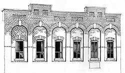
The Anderson Block - Illustration by David Peacock
|
The first sign of the disaster came at noon on December 1, when a shot rang out on Colborne Street . Thomas Howarth had committed suicide in his office next to the Oakville House. A run on the banks ensued, with Anderson's bank failing on Dec. 18. Nearly everybody in town was affected by the failures, most of them devastatingly. The Andersons' 500 depositors, many of whom had entrusted their life's savings to the bank, ended up with 2 1/2 cents on the dollar. 17 Cyrus Anderson and his sons lost everything: the "Grit Anchorage", the 200 acre farm, the bank, the Anderson Block...
|
Ironically, out of this disastrous event arose the foundations of the Brantwood neighbourhood many TCRA residents enjoy today. See the next item.
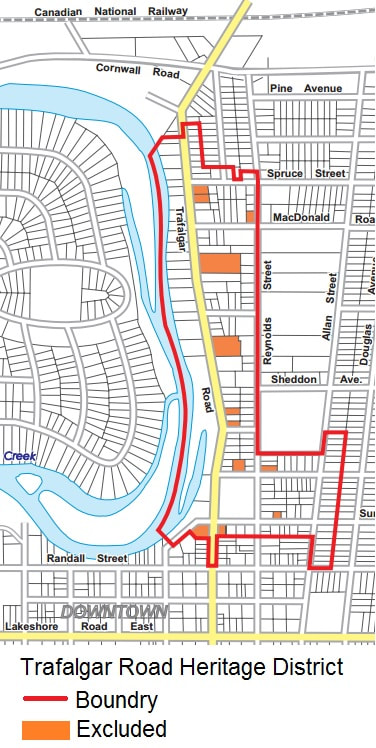
The Brantwood Survey 1907 (#18)
The Bank of Hamilton (now the CIBC?) was the principal creditor in the Anderson Bank bankruptcy and, to help recover its losses undertook a large subdivision on what had been the Anderson farmland - the "Brantwood Survey". The Brantwood Survey was bounded by Lakeshore Road, Allan and Spruce Streets and what became Gloucester Avenue. By 1909 roads had been laid out and graded and new cement sidewalks ran north, south, east and west. Within a few years sewer and water systems were added. Around 1916 the entrances to Brantwood were marked by large square stone pillars on either side of Gloucester, Watson, and Douglas avenues, lending an air of elegance to Colborne Street East.18
Although all the services were in place, houses were conspicuous by their absence for some years. But by dint of much advertising and the untiring efforts of W. S. Davis (see links below*), who was the chief agent of the Cumberland Land Company (which was in charge of the project) as well as being local manager for the Bank of Hamilton, by 1911-12 the area began to fill up.18
"When Spring and Summer arrived, the great attraction was to the many wooded areas in and near town. Nearest at hand was "Anderson Bush" the wooded part of the "Brantwood Survey" between Palmer and Spruce and from Douglas to Gloucester Avenue, and lovely wildflowers grew in the thick woods. Anderson Bush could be reached quickly after school or on weekends by children's ever-present roller skates and bicycles."19 The idea of roller skating in the new growth forest bush that had grown up after the cutting of timber in the 1800's may seem strange, but remember that although the sidewalks for the Survey had been laid out, much of the area remained vacant for many years.
-----------------------------------------------------
* A 1913 sales brochure for the Brantwood Survey, kindly made available in January 2007 by Catherine McDermott, a fifth-generation resident of the TCRA area, is available by clicking on one of the following links. While the focus of its 22 pages is the Brantwood survey (homes of "the rich and famous", then-current development, land and home prices therein, etc.) it also includes data on other aspects of Oakville life at the time, including rail schedules and prices to Hamilton and Toronto, The Oakville Club, and social amenities of the day.
Our thanks to the donor. All such contributions are MOST WELCOME!
The Gloucester Avenue Railway 1912/13 -15 (#19)
As Francis Ahern described it:20
"There was at first no sign that there was ever to be a Gloucester Avenue, even though the other Brantwood streets had been graded and provided with sidewalks, and it was not until 1912-13 that the road allowance was cut through the dense bush up to the northern boundary [of the Brantwood Survey], Spruce Street. The decision to open up Gloucester at this time was made because the long-hoped-for paving of the Toronto-Hamilton Highway [Lakeshore Road] was shortly to be extended to Oakville from Toronto." All materials to build the road would be coming by rail, and using the Gloucester right-of-way through Anderson's Bush to move the materials to Lakeshore Road provided the least inconvenience to residents.
|
"Accordingly, a narrow-gauge track was laid the length of the newly cleared Gloucester Avenue from the Grand Trunk (C. N.) railway tracks down to Colborne Street, and on it a small steam 'doney-engine' with a long string of dump-trucks in tow ran a frequent shuttle service carrying all supplies throughout the local construction of the highway. The ...highway was completed through Oakville in 1915. It may be that not very many of the townspeople realized that all this was taking place in their usually peaceful "Anderson's Bush"... However, I lived then on my father's nine-acre fruit farm on Centre Avenue (now no. 317 Gloucester) and witnessed all these exciting happenings with my very own eyes!".
|
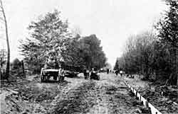
Gloucester Ave. looking south - c1915
|
|
"Grit Anchorage"/Finch-Noyes home/Allan Street Apartments 1870s - present (#20)
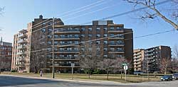
The large home on the north-east corner of Allan Street and Lakeshore Road built in the 1870's by C. W. Anderson (the "Grit Anchorage" - see The Shot Heard Through Town above) is fondly remembered by many Oakville residents as the Finch-Noyes home. Nine years after seizure of the property by the Bank of Hamilton following the Anderson bankruptcy, the property was purchased by E. Finch-Noyes from Hamilton. Francis Ahern describes it as follows: "The lovely Finch-Noyes property, comprising the block from Colborne to Randall Street and from Allan Street to Douglas Avenue, boasted huge trees surrounding a large, white frame-house of unusual architecture. Lovely lawns and smaller trees in the vicinity of the house were contained by a white picket fence. White gates at the corner of Colborne and Allan Streets opened onto a shaded driveway leading to the house, and an entrance at the east end of Church Street led to the stables and the back of the house. The land at the Douglas-Colborne corner was very low-lying and, being fed by springs, was marshy and overgrown with bulrushes and swamp-grass. The house had been the residence of C. W. Anderson until the failure of his private bank in 1902. Mr. J. T. Madden and his family lived here for a few years until E. Finch-Noyes from Hamilton bought the property in 1911. The lovely old home was demolished in the 1960s and a large apartment complex now covers this block." 21 The Finch-Noyes Home |
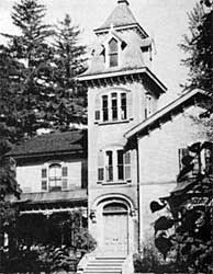
The Finch-Noyes Home
|
|
(John Caulfield Smith, spearheaded the fight by area residents against the demolition of the magnificent old home to build what is, in the opinion of one local architect, "the most inferior building designs in the history of the town.")
|